
Blue Ridge Cave Trail #608
Arizona's White Mountains
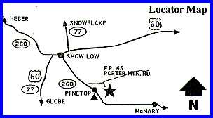
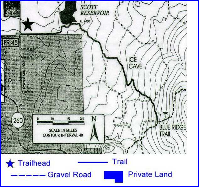
Attractions and Considerations: The Blue Ridge Cave Trail offers a variety of points of interest in a relatively short distance. From the trailhead on Porter Mountain Road (FR 45), one will experience a riparian environment along Porter Creek and Scott Reservoir before climbing to higher elevations. Wildflowers along the trail include sego lily, fleabane daisy, groundsel, yellow salsify, stinging nettle, Indian paintbrush, purple bush penstemon, and Rocky Mountain iris. Trees along the trail include ponderosa pine, Gambel oak, alligator juniper, Utah juniper, and Rocky Mountain juniper. Some other interesting plants in the area are wild parsley, prickly pear cactus, penny cress, pussy toes, wild grape, golden pea and several interesting water plants. Nature observers will find several species of birds and an occasional deer or elk. Parts of the trail are quite rough due to the volcanic origin of the rocks and soil. Just beyond the mid-point of the trail is the Blue Ridge Cave, a lava tube which was probably discovered by sheepherders prior to 1910. The first trail to the cave was marked by a group of local Boy Scouts around 1920, and it has been visited regularly since that time. It is also known as the "ice cave," probably because of the constant flow of cool air (around 52 degrees Fahrenheit) leaving the cave. It is probable that the entrance to the cave, which is simply a hole in level ground, was created by a cave-in. The cave has been fenced off and locked for protection and preservation by the Forest Service. Access and trailhead location: From Lakeside Ranger Station, drive 0.2 miles towards McNary on AZ 260. Turn left onto Porter Mountain Road (FR 45). Drive 1 mile to the trailhead on the right, immediately before FR 45 crosses Porter Creek.
For more information, please feel free to contact:
White Mountains Online wishes to express our appreciation to the USDA Forest Service, Lakeside District and the Town of Pinetop-Lakeside for providing this information! |
||||||||||