East Baldy Trail #95
|


|
Elevation: From 9,300 to 11,200 feet above sea level from bottom to top. |
Season: May through October. Snowdrifts often block upper portions of the trail as late as June. |
Use: Heavy from Memorial Day through Labor Day. Moderate at other times. |
|
Length: About 14 miles round trip. |
Difficulty: Moderate. |
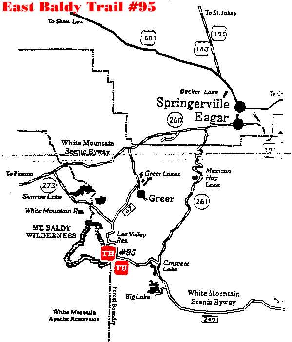
Access: The trail begins in Greer at Government Springs, near the end of Forest Road 575. |
Description: There are two trailheads, both of them off AZ
273. The main trail head is on the north side of the East Fork of the Little
Colorado. Phelp's Trailhead used to be on this site. A secondary trailhead is
located at Gabaldon Campground. The trails merge within a quarter of a mile of
their respective starting points.
The two trails merge near the
wilderness boundary. The trail follows the East Fork of the Little Colorado
River through a long meadow. The river has several pools created by beaver dams
which are usually good fishing spots. If you don't have a fishing pole, or even
if you do, maybe what you'll catch is a glimpse of a beaver going about its
daily tasks. If you don't see one of these large, shy rodents you can always
console yourself with the variety of wildflowers that blanket the meadow from
late spring through the summer.
After following the meadow for about
a mile and a half, the trail enters the timber. Here is where it begins to
climb, and what a climb it is. The trail winds up through a maze of sandstone
boulders and stands of mixed conifer. In a half mile of climbing, you will gain
800 feet in elevation. As if this were not enough reason to catch your breath,
try the view. A reward usually comes to those who strive, and your reward will
be a truly panoramic view. This view includes portions of the White Mountain
Apache Reservation, Big Lake, Crescent Lake, a sizable chunk of the Black River
Valley, Escudilla Mountain, the Blue Range and on into the Gila National Forest
in New Mexico. Few vantage points on the Forest offer a view like this,
hopefully you brought a camera.
From this point, the trail follows a
ridgeline on a continuous uphill grade, thought it is a far more gradual climb
than the one you've just been through. As the trail climbs, it alternates
between timber and bare, rocky areas. About seven miles from the trailhead,
this trail merges with the one from Sheep's Crossing. The two come together in
a saddle below Mount Thomas, nearly to the top of Mount Baldy. The summit of
Mount Baldy itself is located on the White Mountain Apache Indian Reservation
is closed to all non-tribal members. From this point you can choose to continue
on to Sheep's Crossing, about seven miles away, or to return the way you came.
Many people like to hike up one trail and down another and make their lives
easier by parking or shuttling their vehicles at each of the trailheads.
Attractions and Considerations: Please sign in at the trailhead register. Carry your own water or purification equipment and do not drink untreated water. This is a wilderness trail. Rules pertaining to wilderness areas apply and are enforced. No motorized vehicles, mountain bicycles or power equipment are allowed in the wilderness. Please follow low impact camping techniques and leave no trace of your passing. For more information, refer to the Wilderness section of the USDA Forest Service. Group size limits are 12 for hiking and riding and 6 for camping.
|
Click here for map!
|
For more information, please feel free to contact the USDA Forest Service, Springerville Ranger District at 928.333.4372 or you may write us at 309 S. Mountain Avenue, Springerville, Arizona 85938
White Mountains Online wishes to express our appreciation to the USDA Forest Service, Springerville District for providing this information!