![]()
Los Caballos Trail #638
Arizona's White Mountains
|
|||||||||
|
Elevation: 6,300 - 6,940 feet. |
Season: Spring to early winter |
Use: Moderate |
Length: 14 miles |
|
Difficulty: Difficult for hiking. Difficult for horses. Difficult for bikes. |
|||
Attractions and Considerations: Los Caballos is one of the longest trails in the White Mountain Trail System. The trail winds its way through beautiful ponderosa pine and pinon-juniper woodland at elevations much lower than the east side of the district. Because temperatures can be several degrees higher here with less shade, some people may prefer to use this trail in spring, fall, or even winter. This trail offers several scenic views of the Mogollon Rim and the White Mountain Apache Reservation to the south.
The trail is difficult because of steep, rocky sections and the length of the trail. Be sure to bring more water and food than you think you will use, and plenty of sunscreen. If you are prepared, you'll have a great time; if not, it could be a long, grueling day.
There are options for those who want to do a shorter loop. One can follow the trail from the trailhead to where it crosses FR 136, then return via this road. Another option is to continue to where the trail corsses FR 140 and follow that road back to 136 and the trailhead. Be sure to pick up a map at the ranger station.
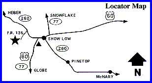
Access and trailhead location: From downtown Show Low,
drive two miles west. Turn right on AZ 260 towards Payson/Heber. Drive 2,9
miles. After crossing Bagnal Draw, turn left on to FR 136. FR 136 is not
marked. Drive 0.6 miles to the trailhead on the right.

Click here
for topographical map!
File size: 90K
Use your browser's back
button to return to this page!
|
Suggestions: Bring
Your Own Water! |
For more information, please feel free to contact:
- TRACKS, c/o Town of Pinetop-Lakeside, Parks & Recreation Dept., 1360 N. Niels Hansen Road, Lakeside, Arizona 85929, Telephone: (928) 368-6700
- USDA Forest Service, Lakeside Ranger District at 928.368.5111 or you may write us at 2022 W. White Mtn. Blvd., Pinetop-Lakeside, Arizona 85935
White Mountains Online wishes to express our appreciation to the USDA Forest Service, Lakeside District and the Town of Pinetop-Lakeside for providing this information!