West Baldy Trail #94
Arizona's White Mountains
|
|
Elevation: About 9,000 feet at the trailhead and 11,200 feet at the Reservation boundary near the summit. |
Season: May through October depending on snowpack. Sometimes snowdrifts block portions of the trail as late as June. |
Use: Heavy from Memorial Day through Labor Day. Moderate at other times. |
|
Length: 14 miles round-trip from parking lot at Sheep's Crossing. |
Difficulty: Moderate. |
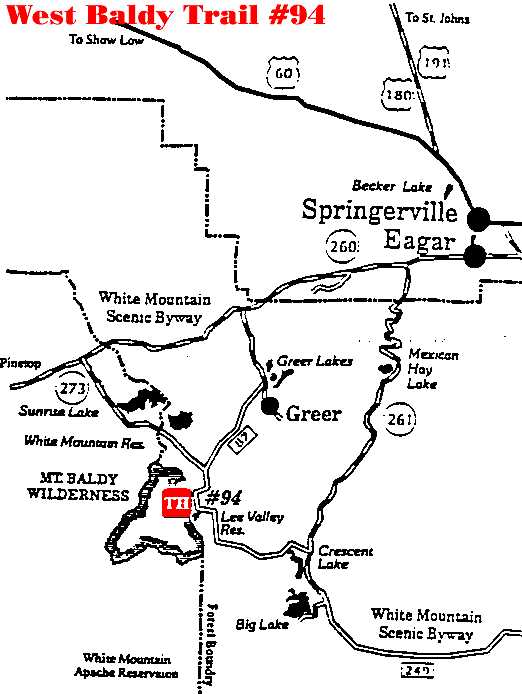
Access: The trailhead is located at Sheep's Crossing, off the gravel portion of AZ 273. |
Description: This is the second half of Trail #94, which
begins in Greer off Osborne Road. For a full description of that trail please
refer to West Fork Trail #94.
The trail
starts just out of the parking area and through the gate. Please, take a moment
to sign the visitor register. The trail is easy to follow as it cuts across a
wide meadow and edges up to the West Fork of the Little Colorado. The trail
follows the stream for the next two miles, climbing gradually. This stretch is
the most heavily used portion of the trail and quite possible the most heavily
used trail on the Forest. If you have a problem with lots of other hikers, then
avoid this trail on weekends and holidays. as the trail begins a more
noticeable climb, the crowds thin out quite a bit. The trail crosses the West
Fork over an old bridge and continues its uphill grade. The ascent is no
vein-popper, but it can still be taxing due to the steady climb and high
elevation.
The trail crosses meadows and winds through a thick forest
setting dominated by spruce, fir and aspen. Beaver dams dot the stream and
fishing on the West Fork is generally good. As you work your way up, the trail
becomes a series of switchbacks. Please stay on the trail and resist the
temptation to make your own shortcuts. This damages the soil, scars the land
and causes erosion which could wash out the established trail and bring silt
into the creek. The West Baldy Trail merges with the East Baldy Trail in a
saddle near the Reservation boundary below Mt. Thomas. At this point you can
see some new country and continue down to the other side, or turn around and
see the trail you just came up from a different angle. Each is a 7 mile hike
from this point. Many hikers park a vehicle at the Sheep's Crossing trailhead
and another at the Phelp's trailhead as shuttle vehicles. The summit of Mt.
Baldy is on the White Mountain Apache Reservation and is closed to all
non-tribal members. Please respect their customs and laws and do not travel to
the top.
Attractions and Considerations: This is a wilderness trail. Rules pertaining to wilderness areas apply and are enforced. No motorized vehicles, no bicycles and no power equipment are allowed in the wilderness. For more information on rules and ethics governing wilderness areas, please refer to the general information section of the USDA Forest Service Wilderness guide. Carry your own water or bring water purification equipment. Do not drink from local water sources, it is untreated. Please sign in and out at the trailhead register. Let someone know where you'll be and when you expect to return. Group size limits are 12 for hiking and riding and 6 for camping.
|
Click here for
map! |
- Return to Greer, Springerville & Eagar Trails Index
- White Mountain Trails Overview
- Cities & Towns
- White Mountains Online
For more information, please feel free to contact the USDA Forest Service, Springerville Ranger District at 928.333.4372 or you may write us at 309 S. Mountain Avenue, Springerville, Arizona 85938
White Mountains Online wishes to express our appreciation to the USDA Forest Service, Springerville District for providing this information! Page Design & Graphics by White Mountains Online. Copyright © 1999. All rights reserved.