  Arizona's White Mountains Arizona's White Mountains
The White Mountain Trail System was conceived and designed as a
way to increase recreational opportunities for everyone who enjoys the forest
through hiking, biking, and horseback riding. With a lot of community
involvement and a great effort on the part of volunteers, a series of loop
trails and connectors have been constructed. They vary greatly in length and
difficulty. The type of tread ranges from level to steep and rocky.
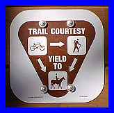 These trails are open to mountain bike
riders, horseback riders and visitors hiking on foot. Trail users should
remember to respect each person's right to be there and to follow multiple use
trail etiquette: bicyclers yield to hikers and both yield to pack and saddle
animals. These trails are open to mountain bike
riders, horseback riders and visitors hiking on foot. Trail users should
remember to respect each person's right to be there and to follow multiple use
trail etiquette: bicyclers yield to hikers and both yield to pack and saddle
animals.
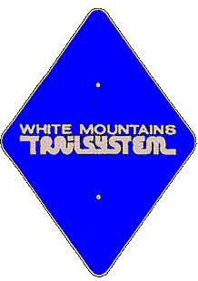
Trails are marked with blue diamonds, often bearing directional
arrows, trail numbers, or colored dots. Yellow dots indicate a short route back
to the trailhead. Green dots indicate a connector trail. Red dots indicate a
side trail to a point of interest or a particularly scenic vista.
 The trails frequently make use of and
cross existing roads and travelways. It's very easy to miss a trailmarker and
lose the trail. Expect this. If you become confused, backtrack to the point
where you lost the trail. Portions of the trailsystem use forest roads. Be
aware of possible vehicle traffic. The trails frequently make use of and
cross existing roads and travelways. It's very easy to miss a trailmarker and
lose the trail. Expect this. If you become confused, backtrack to the point
where you lost the trail. Portions of the trailsystem use forest roads. Be
aware of possible vehicle traffic.
A partnership with the Forest Service, Pinetop/Lakeside
TRACKS and the Arizona State Parks Heritage Trails
Fund have helped build these trails. Volunteers have built the majority of the
White Mountain Trail System. If you or your community service group is
interested in volunteering, contact the U.S. Forest Service or
Pinetop/Lakeside Parks and Recreation
Department. Be sure to check with the Lakeside Ranger
Station for current information on trail conditions!
For more information, please feel free to contact
the USDA Forest Service, Lakeside Ranger District at 520.368.5111 or you may
write us at: 2022 W. White Mtn. Blvd., Pinetop-Lakeside, Arizona 85935
|