Eagar
|
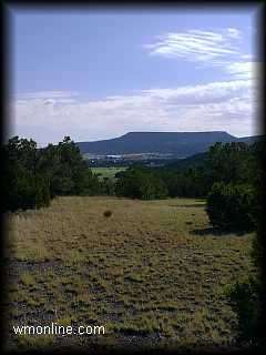
In 1888, the town, 221 miles northeast of Phoenix at elevation of 7,000 feet, was established under the name Union to unify the small settlements in the area. The name was changed to Eagar in 1892, the Post Office was established in 1888, and the town incorporated in 1948. Eagar is on U.S. 180, the direct link between I-40 and I-10, at its junction with U.S. 60. Eagar's southern border is the 2,112,985-acre Apache-Sitegreaves National Forest which contains four rivers, 24 lakes and reservoirs, 680 miles of trout streams, as well as primitive areas for pack trips and hiking, and hunting for big and small game. There are prehistoric cliff dwellings, scenic meadows, ghost towns, mining communities and scenic mountain drives. Sunrise Ski & Recreation Park, owned by the White Mountain Apache Tribe, is 20 miles southwest of Eagar. It offers skiing and sledding, sight-seeing and activities for year-round recreation. Alpine and Greer, each approximately 20 miles from Eagar, have three supervised cross-country ski trails of varying difficulty. U.S. Highway 180-191 has been officially designated "Coronado Trail." The historic and scenic qualities of this route will enhance any motorist's enjoyment of the area. The Little Colorado River originates in Greer 14 miles west and flows through Eagar on its way north and west to Grand Canyon. Along the river are deer, elk, antelope, small game and birds.
| Community
Profile |Scenic
Attractions | This page prepared from Arizona Department of Commerce profile on the City of Eagar dated February 2001 and published with the permission of Round Valley Chamber of Commerce. |
 Eagar, located on the
northeast slopes of the White Mountains, is set against a national forest of
ponderosa pines. Its history dates to the late 1800s when John Thomas Eager,
his brothers Joel and William, and the Robertson family homesteaded in Round
Valley.